At least the cluster of boulders I found myself in afforded some protection from rock fall. As my companions struggled down to join me I shouted ‘I reckon we could bivvy here.’ As they joined me they reluctantly agreed. While it felt a tad safer in our boulder ‘refuge’, the thought of an unplanned night out in minus five snowfall did not inspire any joys of being in the hills. It was 6.30pm, Thursday June 20th – one of the longest nights of the year lay ahead. 13 hours of darkness to endure was definitely going to be type two fun at best. Hopefully not hypothermia type three.
So how did we get ourselves into this predicament? We’d known that the weather was due to deteriorate and we knew that the route out from Plateau Hut, over Cinerama Col, down Boys Glacier and then along Tasman Glacier would take a good twelve hours – Caro had already done it in summer conditions on an NZAC high alpine skills course a few years back. Yet we didn’t leave Plateau Hut until dawn, knowing that we had just ten hours of daylight to work with.
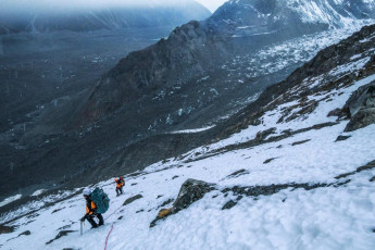
This image - on the snow covered scree below Boys Glacier. As the Tasman Glacier slowly drew closer, so did night fall. Then it began snowing.
On the Tuesday, two days before, Simon Williamson, his partner Carolyn Ellis and I had taken a chopper up to Plateau Hut. Our Wellington Section NZAC trip objective was the standard east ridge route on Mount Dixon. The forecast for the following day was bluebird and avalanche risk was rated low. But the weather window was short, with a deterioration expected on Thursday afternoon. Unless things improved, our plan was to climb on Wednesday and walk out Thursday. This image - Approaching the Grand Plateau. Hochstetter icefall is bottom left, Mt Dixon centre skyline and Plateau Hut the dot at centre right.

Up at Plateau Hut we shared the chilly (water pipe freezing) space with just two others. Pip Walter and partner Simon Middlemass had stolen an evening away from their busy lives running Unwin Lodge for a romantic snow escape. Woops, sorry guys. If three’s a crowd then maybe five’s a party. It was very nice to catch up with them. Of course we also shared our plans and they kindly offered that one of them could drive our rental vehicle up as far as possible beyond the Blue Lakes carpark at the head of Tasman Glacier. ‘We’ll leave the key behind the rear wheel furthest from the road’ Simon explained. Awesome – that would save at least three kilometres of gravel bashing at the wrong end of our walk-out day and solve our problem of how to get all the way back around to Mount Cook airstrip.
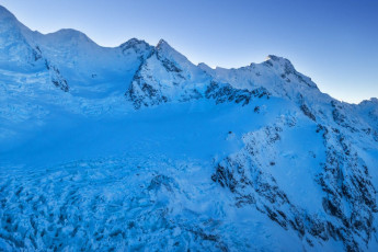
This image - Dusk view from Plateau Hut to, from left, Malte Brun, Arguilles Rouges, Mt Nathan, Mt Chudleigh and Mt Johnson.
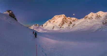
Sometimes the crux of the east ridge of Dixon is just getting across the schrund at the base of the steep chute giving access to the east ridge. Therefore we decided to get underway just a couple of hours before dawn so that, by the time we reached the schrund, it would be light. As it turned out, the dawn sky was crystal clear and a full moon illuminated the Plateau as well as any floodlights could. I did feel pangs of regret for not getting away earlier as we made slow progress plugging through very soft snow. Though the temperature had fallen well below zero during the night the snow was super-dry, unconsolidated powder. This image - At dawn on our approach to Mt Dixon, looking south to the ANZACs, Mounts Cook, Dampier, Vancouver, Silberhorn and Tasman.
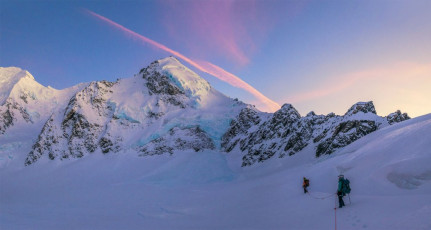
At least the conditions favoured photographers. It’s a privilege to just be up on the Grand Plateau at all during a beautiful calm dawn. As we approached the base of Dixon I rationalised that the alpenglow spectacle we enjoyed had already become a consolation prize for me, if we didn’t manage to complete our climb. This image - Approaching Mt Dixon (3,004m, left of centre).
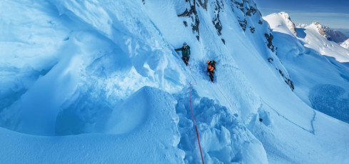
We reached the schrund after about two and half hours of tiring plugging. I managed to lead across on the climber’s right, but it was immediately apparent that the snow was in horrid condition and protecting ourselves as we climbed, or more importantly descended, was going to be near impossible. ‘I don’t like it guys.’ ‘Just go a bit further and see if the snow improves’ Simon encouraged. Up I went, then Caro crossed the schrund and, 15 metres of rope later, so did Simon – not that the rope provided any real protection as three effectively unanchored climbers wallowed upwards. After a failed attempt to put in a rock anchor at about 2,400 metres, we all agreed that this wasn’t going to be our day.
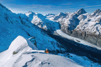
‘Ah well, let’s go up that then’ consoled Simon, pointing to the high point north of Glacier Dome. This was a simple plug up a gentle snow slope, still requiring a fair bit of grunting for the alternating leader. It steepened and hardened up just before the top, which gave us an excuse to get in a bit of pitching practise. On the 2,452 metre top the views were worth the effort. Many of the big names and many lesser known peaks spread out before us under a cloudless sky. Nice, very nice indeed. This image - A view to the head of the Tasman Glacier, from Point 2,452m.
That evening back at a deserted Plateau Hut the radio sched revealed no new weather news, so our thoughts turned to our walk out next day, before the weather was forecast to get ugly on Friday. Given the snow condition, our main concerns about our descent route focused on crevassed terrain across the Plateau, and particularly the steeper southern side of Cinerama Col. We figured that if we could get over that and down the Boys Glacier before nightfall, then we should be fine. First red flag!
Thursday dawned with a soft breeze and the first signs of weather-changing cloud. We set off in glacier travel mode right on dawn, so that picking a route through the crevasses would be easier. It was another great day to be in the mountains, especially the biggest ones in New Zealand.
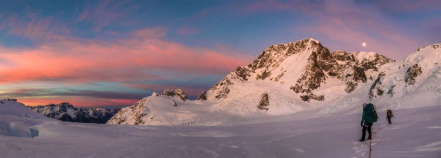
This image - Crossing the Grand Plateau. As the sun rose the moon set behind Dampier.
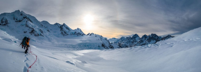
Simon led off and picked an efficient route across the Plateau, up underneath Mount Cook’s east face. The going was still arduous – soft, sometimes shin-deep snow. In places an unpredictable crust had formed, sometimes supporting our weight, other times not. Without anything human-made to compare with, the landscape proved to be much bigger than it appeared. It took us about four uneventful hours to reach Cinerama Col. This image - At about the halfway point on the route to Cinerama Col.
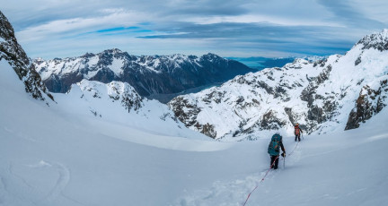
From the Col we got our first look down into the vast Caroline Glacier, fed from the icefall of the intimidating Caroline Face. Visibility was still quite good, although when looking east, the light was deceptively flat. We could still see most of the route down, then along an upward sloping shelf beneath the ANZAC Peaks, to a small dip at 2,180m. On the far side of this lay Boys Glacier. The unknown was what lay just over the convex bulge in front of us. The answer, unsurprisingly, was crevasses, but Simon was able to pick a way through these with only one ‘ah-oh, I’d better tread very softly because it’s black down there, please hold me’ moment. This image - The view south over Cinerama Col (2,333m) to the Caroline Glacier.
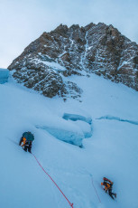
Our route picked a way down through a steep crevassed section as we worked our way around to the left below the ANZAC Peaks.
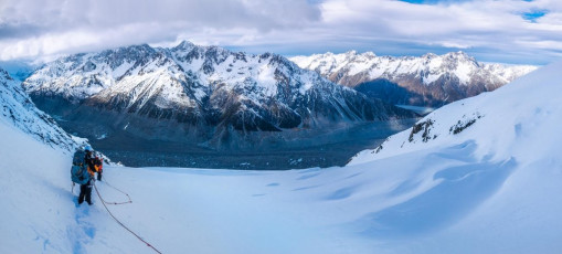
By 1pm we were at the top of Boys Glacier as high cloud began descending. The Boys required some care with route finding to avoid slots and some rocky bluffs, but based on Caro’s vague, few-year-old recollections, we made our way down with only a couple of backtracks.
This image - Looking northeast, from about 2,150m, down Boys Glacier to the Tasman Glacier another 1,000m below.
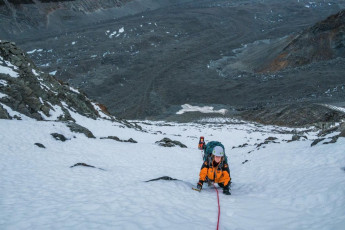
At 1,500m the glacier gives way to steep scree. For us the top of this was snow covered, allowing for quicker down climbing to begin with. Once the snow thinned though, the going got treacherous. Then it began snowing as the last light of day faded and a biting wind picked up. Which brings me back to our freezing bivvy.
This image - The steep chute leading down to the scree beneath Boys Glacier.
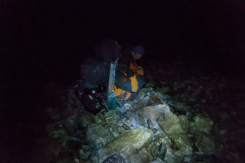
All of us were fully clothed in almost everything we had, with boots still on. I was alone in a bivvy bag trying to control violent bouts of shivering, pondering how we could last like this for 13 hours. Simon and Caro shared a bothy bag slightly uphill behind a protruding boulder. As the minutes dragged by, frequent bursts of laughter drifted my way between wind gusts and the ominous rattling and thudding of falling rocks. I couldn’t see even the slightest shred of humour in our situation, yet they seemed to be having a rip-roaring time. Actually, they weren’t. Caro confessed later ‘It was a case of laugh or cry.’
At about 11.30pm the wind eased, clouds cleared and a still near-full-moon lit things up. Now we could see that Tasman Glacier was not far down at all. ‘Let’s get out of here while we still can’ exclaimed Simon. No argument there! I set off first to get well ahead while they stashed their gear, so as to avoid rock fall from them as they descended.
This image - About to depart our 1,050m bivvy site at 11.30pm.

Thud. Rat-tat-tat. Thud. This was more frightening than earlier when Simon and Caro were unavoidably dislodging rocks from above. At least then it was predictable and I could take evasive action by staying beyond their fall lines. Now the rock fall was random. Smack. Yellow sparks flew as a lethal rugbyball-sized projectile collided with another stationary boulder about ten metres to my true left. Several times I heard rocks falling directly above and just flattened myself against the rocks and hoped. ‘This is not good. I’ve got to get off this slope!’ The quickest way for me was to bumslide – uncivilised, not elegant, but in the dark, slippery, treacherously loose rock, the quickest. Once moving I was amazed how quickly the warmth flowed back through me. Adrenalin undoubtedly also had something to do with it. Surprisingly quickly I reached a reassuring flat space on the western edge of Tasman Glacier. I picked a boulder to sit on across the far side, pointed my head torch in Simon and Caro’s direction, and stayed clear of the occasional boulder that bludgeoned its way down into my clearing. As Simon and then Caro joined me a sense of relief came over me. ‘I don’t ever want to be on such unstable terrain again.’ Second red flag!
This image - in the absence of any photography during our escape, here's another from Cinerama Col the day before, looking north.
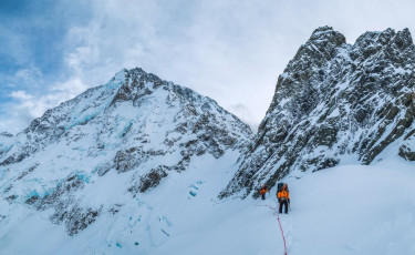
Moraine. We often discuss how glacial moraines have become far bigger than a few short decades ago, as a warming climate has melted vast amounts of glacial ice, while less new snow loads on top to replenish it. None of our party had been on big moraine, like that of the Tasman Glacier, in wet conditions before. We knew how loose and rubbly moraine walls are, but we really had no idea what lay ahead for us this long cold night as we set off along the undulating rubble-covered surface of Tasman Glacier.
Having agreed that it was better to keep moving than resume a miserably cold bivvy for another six or more hours, the thought of a nice cosy Ball Shelter not far away also spurred us on. Aside from warmth, we now also craved water. Because we’d been so sure that we’d complete our descent from Plateau Hut in one long day we hadn’t brought a cooker with us, so had no way to melt snow or ice. Now we were paying for this as the irony of being surrounded by so much water, yet having none to drink, played on our minds – rime of the ancient climbers.
This image - A view back from the small saddle between the Caroline Glacier and Boys Glacier - our route down from Cinerama Col is all visible apart from the Col itself, which is hidden by the south western end of the ANZACs. The east ridge and Caroline Face of Mt Cook are left.
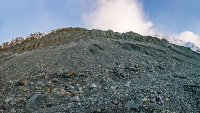
After an hour or more of stumbling progress Simon checked his GPS to see how far we were from Ball Shelter. His device confirmed that we were only 200 horizontal metres away. Just one small problem – about 120 vertical metres of moraine to climb. The moonlight gave us a vague insight into what route up might be best, but it soon became frighteningly apparent that almost constant rockfall was going to dictate where we climbed. The only remotely safe way up was to stay on a spine between two chutes, in which lethal rocks constantly rumbled down.
Being on moraine in wet conditions was a revelation for me. I’ve never been on anything more unstable in my life. The scree below Boys Glacier now almost seemed tame. When I think of it now, my mind boggles at the thought of being on moraine during an earthquake. At a sleep and water deprived stage we were also starting to run low on energy, especially Caro, who is physically small and was, on a ‘pound for pound’ basis, carrying the biggest load. I led up in a heightened state of alert. Poor Caro was just too exhausted to care. All she wanted was to get to Ball Shelter, but had to take agonisingly long rest stops as the rocks tumbled down either side of us. Simon and I resigned ourselves to our plight. We couldn’t abandon Caro or even climb ahead at speed, for fear of sending rocks down on her.
As we slowly got closer to the rim we agreed that I should forge ahead to confirm if our route was going to get us up. With less than 20 vertical metres still to go I reached the point where our silty spine reared up like a barrier of wet, course concrete. If I pushed against the surface water oozed out. ‘Definitely no go up there’. Just then another white rugbyball-sized rock thudded into view in the chute to my climber’s left, coming to rest beside me as if to taunt ‘Go on then, try it, come up this way.’ I poked my nose cautiously around the spine to see a truly unpleasant rim rearing up – steepest right at the top. No way Jose! ‘I know this is not what you guys want to hear, but we can’t get up this way. We’ve got to retreat’ I yelled down to them.
This image - The moraine we all but climbed in the dark.
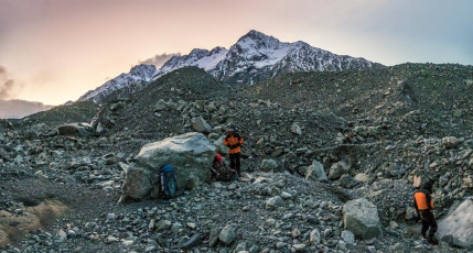
Back down on relatively flat ground again on the western edge of Tasman Glacier, time dragged as we shivered for another four hours until daybreak. As luck would have it, the weather began to improve rather than deteriorate as forecast. I was again amazed to see how, as soon as rain and snow ceased and sun shone, the moraine seemed to miraculously lock up. There was virtually no rock fall as we made our way along its base towards the terminal lake, searching for the best escape route. As we went tiny reservoirs of delicious water appeared in rock depressions – a few sips each time was better than nothing. We were surprised to see a helicopter flying up the centre of Tasman Glacier, thinking ‘that’s quick for the tourist operators to be up again after poor weather – another sign of the times’.
This image - At dawn, our second bivvy spot on the western side of Tasman Glacier.
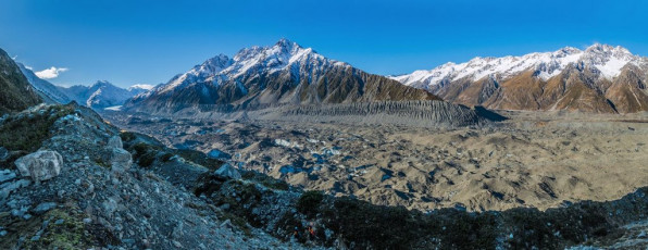
About 10am we decided it was time to face the music and start back up the moraine wall. Caro recalled how she had traversed up at about this point last time. In reality our traverse turned into a direct scramble upwards towards what looked like a weakness in the steep rim. I arrived first below a gloomy 25 metre section with promising sunlight on the rim. One quick test of my boot on the steep surface told me that I’d need crampons to have any chance of getting up. So I dropped my pack and got prepared. Once Simon and Caro joined me Simon put me on belay and up I went. It was a strenuous and un-nerving lead. Rock handholds were nonexistent – any applied pressure just pulled them out of the damp slope. Reaching a safe stance at the top seemed ridiculously more of an achievement than it should, but finally I knew our moraine dancing was over. Just beyond a much gentler stretch of moraine was the Ball Shelter trail. By the time I’d belayed Caro up, then we two hauled her and my packs up and I belayed Simon, with pack, up it was about 1pm. We all felt exhausted. After Simon caught his breath he asked ‘Where’s your rope Peter?’ ‘Clipped to you. Not!’ I answered. He’d used my rope to manoeuvre our packs from below when they got snagged as we hauled them up. The problem was that he forgot to clip it to him when he came up himself. ‘You get to climb the crux twice Simon, at least without your pack this time.’
This image - Finally, safe up on the moraine lip about 130m above Tasman Glacier. Just on the far side of the lip was my 25m pitch using crampons - no photos due to the focusing nature of the terrain.
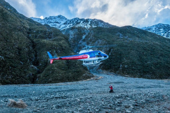
Two hours later we felt very relieved to find our parked rental car. Pip and Simon had made good on their word. In typical Pip fashion much more so in fact ̶ in the front seat sat a thermos of chicken soup, coffee and cookies. Just one problem, no key under the back wheel furthest from the road, or anywhere. As we scratched our heads and pondered the horrible prospect of a very long walk out, the sound of a helicopter grew louder. Into view it came. Desperately we waved and gave thumbs-down signs towards our car. The chopper swung around and landed close by. Out jumped a fit looking young man who purposefully strode over to us. ‘Where the hell have you guys been? We’ve been searching for you all day’ exclaimed Jono Gillan, SAR Supervisor of the DOC/local winter response team. Ah, so that chopper wasn’t a tourist operator after all!
Jono wasn’t angry, just mystified. We shared our story and off Jono and pilot Richard Kidd went to retrieve our car key. It wasn’t there because, after Pip parked our vehicle, she had walked on towards Ball Shelter hoping to find us, to no avail. She called that information in to the SAR team and they picked her and the car key up by chopper.
This image - At 3pm, just as we reached our parked vehicle about 3kms north of Blue Lakes carpark, a helicopter appeared. A SAR team had been searching for us all day.
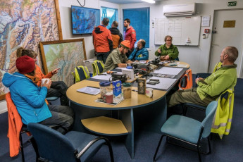
Soon reunited with our key and, after demolishing Pip’s heavenly chicken soup and other treats, we drove into Mount Cook Village to debrief with the SAR team. Along with Jono, Ray Bellringer (Incident Management Coordinator), Lee MacIntosh, Lewis Ainsworth and Madonna Fraser were all there to talk with us over cups of tea and biscuits. While we hadn’t activated our PLB and were able to get out under our own steam, DOC had raised the alarm based on knowing we were overdue and that the weather conditions were dangerously bad. We felt immensely grateful to the dedicated team for all their efforts on our behalf; and reassured to see firsthand how alert and responsive our SAR people are.
The SAR team did not scold us. They just wanted to understand fully all the facts. We on the other hand did some soul searching over the next couple of days and concluded that we did make some mistakes. The main one was to underestimate the difficulty of moraine travel, especially when we knew we faced deteriorating weather. This alone meant we left Plateau Hut later than we could have and we didn’t carry a cooker or full camping gear. Our focus was mostly on safely passing crevassed terrain, which proved to be much less challenging than being on steep scree and moraine in dark, wet conditions. Our price was to endure the longest night of our lives. And it could have been much worse.
This image - At the SAR debriefing. While we hadn't needed rescuing, given the weather and terrain, we could have. We greatly appreciated the efforts that the SAR team made on our behalf.


