


Those who went tramping in the Tararua Ranges over the 2009 Easter may well have noted the north to northwest gale that arose on the Monday afternoon.
To the uninitiated, the weather map for the occasion (in Figure 1) shows only a large High dominating the North Island, and, if the wind follows the isobars and goes clockwise around lows, then central New Zealand would be experiencing southwest winds.

The truth of the matter is more complex. The first two rules of weather map reading (one: clockwise around lows; and two: closer isobars equal stronger winds) are insufficient in themselves to give you a proper grasp of the weather.
These next two rules help fill in more. Rule three: wind leaks across the isobars out of high pressure and into low pressure. The amount of this leak is around 15 degrees over the open sea and can be 30 to 45 degrees over flat. In a place like Cook Strait, where the lower atmosphere is channelled from high pressure to low pressure, the leak is 45 to 90 degrees. So that explains the west to northwest wind direction.
Rule four states that wind accelerates when turning around a high, and decelerates when turning around low. Rules three and four can be combined to imply that, in the mid latitudes, the straighter the isobars, the stronger the wind. This doesn’t work near tropical cyclones, but they are special.
Forecasters have a saying for when Highs gets over 1030: ‘It’s going to get dirty’. This seems to be the threshold for issuing a gale warning somewhere around the High. To accommodate that 1030 isobar, all the isobars around the anticyclone periphery squeeze closer together, making a zone of stronger wind.
This squash zone shows clearly in the Quikscat observation map (Figure 2), which also shows how much the wind leaked across the isobars.

Rule number five says that terrain effects can halve or double the wind speed, creating rivers of wind and puddles of calm. Wind gets distorted when blowing over land; it accelerates along avenues, bounces off abutments, contorts around corners, dips down dales, eddies around edifices, follows fiords, gallops through gaps, and sometimes hikes up hills. During quiet summer days, the hot land draws air onshore, creating a sea breeze. On clear nights, cold air drains off the hills and follows the rivers out to sea (katabatic winds).
On Easter Monday, the combination of a High and terrain had a notable impact. High-pressure areas are zones where the air is sinking (partly in compensation for neighbouring zones of rising air). This sinking air warms as it enters the higher pressures closer to the surface. The air may get taken away by the surface winds but it leaves behind a blanket layer of warm air, maybe a few hundred metres thick, with a base that is usually around a thousand metres in altitude. We call this layer a subsidence inversion. Climbers sometimes encounter it as they ascend to the ridge tops, and its relative warmth is welcoming.
At midnight at the start of Easter Monday we can ascertain, thanks to the MetService weather balloon observations taken from Paraparaumu, that there was a 300-metre thick subsidence inversion above the Tararua ranges with a base at around the 800-metre attitude. This altitude is above the site for the MetService station at Rimutuka summit (555 metres), but generally below the reasonably uniform tops of the Tararua range which mostly undulates between 1300 and 1500 metres. During the morning this base rose to reach about 1200 metres by noon, then 1700 metres by day’s end. When the subsidence inversion sits on the ranges, as it was in the morning, it acts as a blanket and a barrier, blocking off the air that belongs to the river of wind which is streaming through Cook Strait. We can see that river of wind in the morning reports from Wellington Airport and Mt Kaukau (rising from 20 to 25 knots), and we can see the dampening effect of the low-lying subsidence inversion in the morning reports from the Rimutuka summit, all less than ten knots (Figure 3).
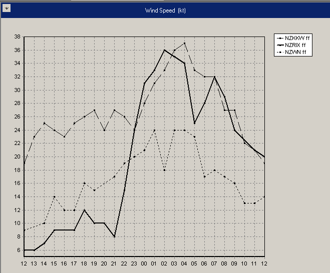
Then, between 9 and 10am, something happened and the wind at Rimutuka summit jumped from 8 knots to a strong 24 knots in just one hour and continued to rise to a gale of 36 knots over the next few hours. This increase in wind speed can be explained by the rising of the subsidence inversion. Once it lifted off the ridge tops, incoming air (which had been piling up on the western side) could freely flow across to the east. The blanket had lifted.
The supply of incoming air is vast compared to the gap between ridge-top and blanket, so – as in any Venturi effect – the wind accelerated through the gap. Sometimes these ‘gap winds’ can be strong enough to blast climbers on the ridge-tops with wind-hurled stones. If you are caught in such a predicament either find shelter or descend to a lower altitude where the effect lessens.
After a while the strong ridge-top winds ease off, either because the blanket effect becomes weaker (resulting in less confined winds that can spread out over a wider area) or because the supply of wind arriving (and driving the river of wind through Cook Strait) dies off.
Subsidence inversions can sometimes be detected as a layer of clear air sitting on top (and trapping) a layer of low cloud. If you encounter a subsidence inversion then keep a watch on its behaviour, because when it pops off the ridge top, a period of strong wind may follow.
Bob McDavitt retired from the MetService in 2012. FMC thanks Bob for his valued contribution as the Bulletin weather columnist over many years. This column was originally published in the August 2009 FMC Bulletin.


