By John and Meg Flux (1995)
We came to New Zealand in 1960 having seen little of our native Scotland, being penniless students. But our son, after cycling most of Europe, told us: “You must do the Hebrides – it’s the best – no people, no traffic, only one road, and you can’t get lost”.
So in 1995, in our 60s, Meg and I packed our bikes (they disappeared in Los Angeles, but turned up later in Amsterdam) and flew to Southampton. The curious crowd that gathered to watch how we put the pieces together cheered as we cycled away — it felt good to be going to islands with “no people”.
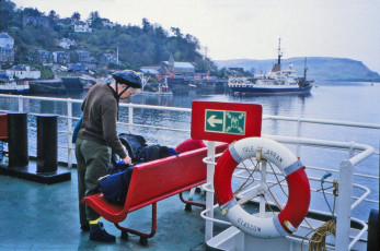
A second-hand car to carry the bikes cost £3500, but the bank had only £10 notes, which took the dealer most of the morning to count. At last we were off to Scotland. We parked in Oban, bought a 3-week ferry pass, and got dropped off to cycle around Arran for 3 days. We stayed in Youth Hostels preferably, our tent if necessary or weather was fine (seldom was), or hotels (seldom available). Early summer we were told was quietest, so we chose 3-20th May; it was chilly, but only snowed twice. “Go south to north”, they said, “the wind will be behind you”. Well, not that year – perhaps we were cycling too fast or Murphy was smiling. Meg’s only complaint over the whole trip was having to cycle down the hills.
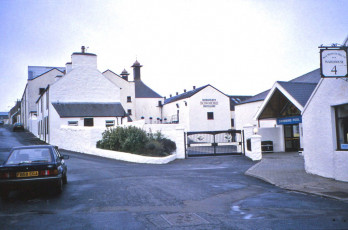
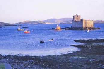
After Arran was Islay, where we toured 7 of the 8 distilleries, just to learn how to pronounce names like Bruichladdich (our favourite malt), Laphroaig, and Bunnahabhain properly. These businesses look after the locals; Bowmore had built a full-size, heated swimming pool – our only dip on the trip. Across to Jura for a short walk – the track looked too rough to cycle – and out to Barra to start the Outer Hebrides part. The evening sun was lighting Kisimul Castle, built in the 1400s by Clan MacNeil, but we needed something smaller. We phoned a B&B and explained to the landlady we would take time to cycle there; “Ah,” she said with the local lilt, “So it’s by by-cycle you’ll be coming!” She was charming, and we soon learned to get our words in the right order. All the school kids spoke in Gaelic (just as we had spoken Doric) and I wonder what they text in now.
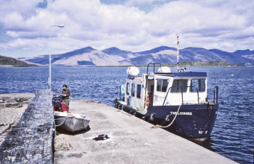
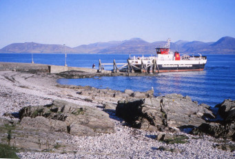
Barra to South Uist had no car ferry, only a small fishing boat which could be phoned up. It came over (with a corpse) and took us on the return. Waves broke over the stern, soaking the bikes, but there was a freshwater hose to clean them on the jetty. Cycling that day was a bit bleak, very flat and exposed to the northerly gale, and the only shelter for lunch was in the ditch. We thought of the Highland clearances, when people were removed to make way for sheep, some being transferred to islands of bare rock, where they existed on fish and seaweed until they had rotted down enough kelp to make soil to grow potatoes. Snow in a wet ditch was nothing to complain about; Meg’s diary simply records “lunch unbelievable”.
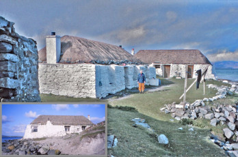
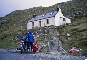
North Uist is connected by a road bridge, and we aimed for the main town, Lochmaddy. The area around is a jigsaw of jagged lakes and islands, well worth a look on Google Earth. We had dinner at the hotel before finding a B&B in the old bank-house. Next morning’s ferry took us to Berneray, which became our favourite island. We cycled the few roads in the south and found our hostel was a pair of lovely old straw-thatched cottages right on the boulder beach. At ground level the stone walls were 6ft thick, narrowing to give window ledges 3ft on the outside and 2 ft on the inside. They had been modernised: stoves with chimneys, instead of a smoky fire on the floor.
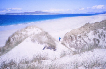
Next morning was Sunday and the minister called to invite us to church. An understanding hostel caretaker warned us the service lasted at least two hours, and the whole population would be indoors reading the good book the rest of the day. The only walking allowed was from home to the church, so if we liked we could go to the west coast beach – three miles of white sand – and nobody would be there. If anyone saw us, they couldn’t tell without giving themselves away. We had those three miles to ourselves all day, walking on the beach and among enormous sand-dunes in brilliant sunshine. Alas no swimming; the water temperature in May would be 9ºC, but it can reach 13ºC in August. It’s said a photo of that beach was used in a tourist guide for Thailand.
The final island was Harris (Lewis is the name of the northern bit) to visit Rhenigidale, a village of about ten people that our son had walked 5 km to because there was no road from Tarbert. According to the UK travel writer Robert Macfarlane, “the track contours audaciously above steep-sided sea-coves, marked with rust-lines of seaweed. Raised stripes of feannagan (lazy beds) are still visible on the fellsides; vestiges from the crofting years”. We got to the hostel on our bikes the easy way: a £1.5 million road had been built with EU money for remote communities in 1990, after a 30-year campaign by the local postie who’d had to walk the path every day, whatever the weather. In the early 1900s the population had increased to nearly 100 as crofters evicted by the clearances tried to make a living there, but they dispersed to better land (New Zealand?) as soon as they could.
A ferry from Tarbert to Skye landed us in heavy rain, but after a few miles a fellow cyclist stopped his car to offer us a lift to Armadale, where you can research your Scottish ancestors. We crossed to Mallaig on the mainland and decided to take the inland route back to Oban via the memorial to the 1745 Jacobite rebellion, which was led by Bonnie Prince Charlie at the head of Loch Shiel, and along the south side of Loch Eil to avoid the main road and Fort William. Then a ferry to the south side of Loch Linnhe, down to Port Appin and ferry to Lismore (just to cycle one more island) before our last ferry crossing to Oban.
We recommend this trip; wet tents and storm gear are so much lighter now. But the ferries may be a little more crowded!