


In 2007, Conservation Minister Chris Carter opened Hakatere Conservation Park in an on-site celebration attended by hundreds of guests. As icing on the cake, he was able to announce the recent Nature Heritage Fund’s purchase of Hakatere Station, which, as newly created public conservation land does, went into the ‘holding pen’ of stewardship classification.
In his announcement, Carter said, ‘There’s a little more paperwork, surveying and background work to be done before it can be formally gazetted, but once that is complete, it will be a significant addition to the new park we are celebrating today.’
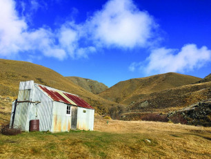
Twelve years later, the 9,100 hectare former Crown pastoral lease remains outside the park. It’s still stewardship land, in the Hakatere Conservation Area, whose boundaries include Lambie’s Stream, the South Branch Ashburton River, and the Potts River. It includes the land around Lake Clearwater. Boundary Stream Hut, a basic eight-bunker built more than a century ago, marks the former run’s northern point.
All those years ago, the NHF got the Hakatere Station purchase right. Under towering skies, it’s a place of moraine terraces, ridges, and outwashes, and short and tall tussocklands and shrublands. Its complex of wetlands is significant. Indeed, Hakatere is part of the wider O Tu Wharekai; this Ashburton Lakes/upper Rangitata inter-montane wetland system is one of three sites in the national Arawai Kakariki wetland restoration programme.
The land’s physical and botanical riches are a kohanga for diverse and special creatures, from a spectrum of damselflies and dragonflies and the boulder copper butterfly, to threatened birds including the black-billed gull, the banded dotterel, and the black-fronted tern.
Hakatere Conservation Area lies within a flawless landscape with views to the upper Rangitata’s braids and Mt D’Archiac on the fringe of Aoraki Mt Cook National Park. There are many easy recreational objectives including Dogs Hill (1,067 metres), Mt Guy (1,319 metres), and the Dogs Range itself.
In former pastoral farming days, Boundary Creek Hut marked a line between winter and summer grazing blocks. It’s a good overnight destination, but is also a great day walk. It’s quickest from Buicks Bridge car park; this route also provides grade two mountain biking. It’s a slightly longer walk from the Potts River carpark.
To reach Hakatere Conservation Area, head west from Mt Somers on Ashburton Gorge Road, which becomes Hakatere Potts Road. The Potts River carpark is about 40 kilometres from Mt Somers. For the Buicks Bridge entry point, turn onto Hakatere Heron Road; the carpark is four kilometres along.
This article is excerpted from the November 2019 edition of Backcountry Magazine titled ‘Forgotten Lands.’ For more information or to subscribe to Backcountry, please visit https://www.fmc.org.nz/aboutbackcountry/.


