At first thought, the combination of mountaineering and packrafting seems a little silly; light-weight inflatables combined with lots of sharp pointy tools!
New Year for me is a time to be in the mountains, preferably somewhere remote, with good friends. The weather being its usual fickle self however, meant our original plan of a West Coast adventure was now off the cards. Where else to go? Fortunately one delve into NZ topo online revealed a whole plethora of places waiting to be explored that would avoid the Westerly weather.
We decided on a one directional trip starting at the head of Lake Tekapo, traversing diagonally alongside the main divide into the head of the Rakaia river where we would packraft back to the Gorge Bridge. The three passes we would cross – Terra Nova, Disappointment and Rangitata Col all featured in my Dad’s infamous Arthurs’ Pass to Mt Cook trip back in the 80’s. I have heard legendary stories about this trip since I was a kid – Pat Bodger tied to a rope swimming across a swollen Frances River, having to climb around the bluffed-out Godley glacier lake late at night and Pete Squires falling into a crevasse on the glacier. All made great stories and gave me a great connection to the areas we would travel.
In our party – Georgia and Pat who were a bit tired coming straight off the back of some Coast-to- Coast training, our faithful friend Cris Lovell-Smith who lives in Germany but hankers after a good kiwi adventure each year, and Chris and myself, adventure bunnies forever.
We rendezvoused at my sister’s place in Stavely and quickly enveloped her large house in a sea of gear. Georgia felt we were breaking her unwritten rule – don’t combine tramping, packrafting and mountaineering – you will end up with sharp pointy things in your raft and you will have to carry a tonne of gear. As soon as our packs were ready it was easy to see she was right – we were going to be carrying a tonne of gear!
The drive down was highly entertaining, mostly because our car would bottom out on the slightest bump or hump in the road – a result of carrying five people and five heavy packs. By midday we were parked at Lilybank station and began the long trudge up the Godley Valley. A man in a 4WD pulled over and asked us where we were headed. When we informed him he nodded enthusiastically that the packrafts would be ‘fantastic’ for getting around the Godley lake and ‘where could he read about this crazy adventure we were undertaking?’ before honking his horn and hooning off. It’s nice to know there are still people out there encouraging mad people like ourselves.

The km’s ticked over slowly as we walked up valley on the 4wd road.
The Godley is a beautiful valley, but the heavy packs and distance we had to walk on the total flat (about 30km) got everyone a bit depressed. A bike would be key… but how to then carry and raft with one??? Late in the day we reached Red Stag hut where Chris and I sat outside and ate crackers. The rest of the party had become strung out, walking for as long as possible before having to stop for reasons such as Georgia described; “my arms have gone completely numb”. There was a group of hunters who had driven into Godley hut and the lady informed us she ‘thought’ we could get there on foot. We were pretty sure if you could drive there then walking might be possible too!

Some tired people sat by a rock and one pouted.
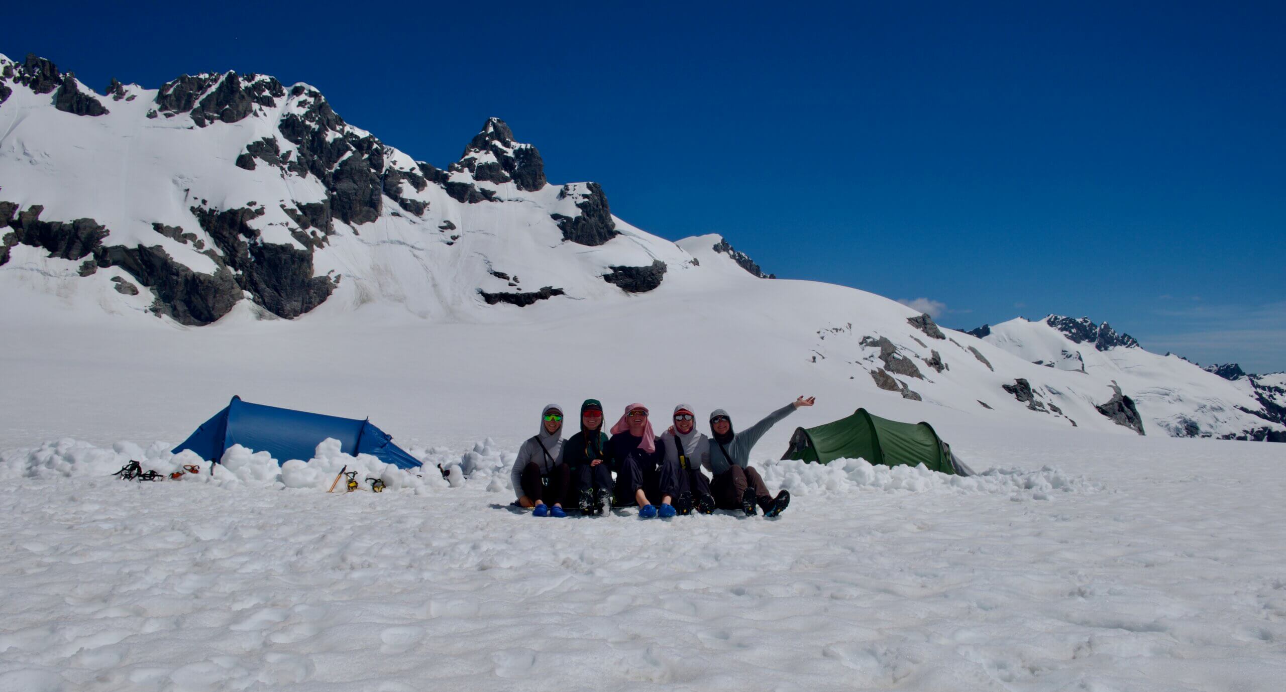
Late in the evening we finally reached the moraine-like hills just before Godley hut. We scouted a way across the silty river and scrambled around its rocky bank to reach the Godley hut just on dark. There was a couple staying there with a dog, so we opted to cook dinner outside the hut on the grassy verge and watch the stars come out. We had a delicious meal including mulled wine and grilled Camembert cheese but unfortunately everyone felt too packsore and dejected to have a particularly jovial New Year’s eve. We crawled into bed at about 11.30 without a single ‘happy new year!’
A big day out over Terra Nova pass awaited… In the morning we knew we needed to get going reasonably early, as we were planning to cross Terra Nova pass and optimistically hoped to make it down to St Winifred hut at the head of the Havelock by the evening. We set off across the rocks, and then down to the Godley glacier lake. In a cold wind we inflated the packrafts and enjoyed an hour’s paddling across the lake, looking smugly up at the crumbling lake-sides – our packrafts coming into their own now that we were in them – not them on us!

Paddling across the Godley terminal lake
Across the lake we were onto the Godley Glacier proper – although this now has the resemblance of a ‘Fultan Hogan-like’ rock-moving site. We looked across the terminus, to see the odd black iceberg sticking out at a weird angle, and deep ice chasms into which the rocks pour down on a regular basis. The rocks underfoot were unstable and you had to focus on each step. At one point Cris toppled over and was trapped beneath a rock – fortunately his mighty strong carbon wing paddle came between him and the rock so we were able to remove the rock and an unscathed Cris was back on his feet.

Our trip photographer, or guinea pig, Crispin, luckily wearing his trusty paddle which saved him from getting squashed under a boulder.
The day wore on and we were still traipsing up and down the moraine; some of the group started to wonder about whether this whole trip was somewhat foolhardy. Fortunately it wasn’t too long after that we climbed the final moraine tower and stepped onto the white ice.

Ascending the Godley Glacier
Terra Nova pass above us looked very straightforward and things became more positive again. A steep snow slope led us to the pass, with a small V notch at the top and then a carved out wind-scoop in the snow on the other side. We set up a small abseil at this point as we could see we needed to descend a steep slope past several small crevasses.

Absiel from Terra Nova Pass
We sent Crispin down first (he seemed to have generally become the trip guinea pig) and then the rest of us followed. The snow was good and firm, easy to kick steps but not too soft. Once we all were safely down the first section we roped up in a two and a three. I lead out with Chris behind me – the idea being that because he is heavier and stronger, if I fell into a crevasse (more likely when I am in front) he would have more chance to hold me. We descended the snow slope to a fairly open crevasse which I decided I would rather avoid, so then traversed right and then back left to avoid another.

Chris demonstrated the drawbacks of carrying pack-rafting and mountaineering gear – we nicknamed him the ‘Gypsy Wagon’.
After a few more weaves in and out of the slots we climbed again to a gentle col. This route avoided descending a steep icefall which drops over the pass on the Northern side. We climbed on snow down a steep ridge and then onto rock again. Just before reaching the flatter moraine we came across a bouldery wall which required some hairy down climbing as most of it was like wheet-bix with large dangerous rocks wedged in amongst it. I found my crampons and ice axe quite useful!

The walk down valley was now quite straight forward but the day was wearing on and we were all becoming quite weary!
On the true left of the St Winifred stream we came across a pleasant flat tussocky area sprinkled with flowering mountain daisies. Given that it was nearly dark this seemed like a sensible stopping point. While Cris and I cooked dinner, Chris spent an hour creating an enormous rock wall on the windy side of the tent, complete with broken dracophyllum branches to act as a wind break on the top. It was quite magnificent, but we did wonder if it wouldn’t have been easier to have shifted the tent to the more sheltered site behind a large boulder about 3m away!

Camping in St Winifred Stream
The wind gave our ultra light, see-through Z Pack tent a good hammering in the night and about half way through it started raining steadily. No one was eager to get going in the morning as the rain and wind continued and we were optimistic it would only be a very short day to get to St Winifred Hut. Once we got going, travel was slow in the thick scrub and spaniard…and then deteriorated to a crawl (literally) when we got into even thicker scrub and had to climb over several steep bluffs. The river was flowing high and looked pretty un-crossable.
At one point we got the rope out to lower packs down a steep bank with the river raging below us. Everyone was feeling pretty miserable and the three kilometer journey took us about three hours! Finally we reached the intersection of the Eric River and the St Winifred. To our dismay the Eric was huge and thundering down alongside us. We needed to cross either the Eric to get to Agony Island bivouac (we could see the little red roof in the distance) or the St Winifred to get to St Winifred hut… or else we were completely stranded.

Setting up a rope-assisted ferry glide across St Winifred Stream
After a bit of scoping we decided that it would be possible to ferryglide the packrafts across a calm(ish) pool on the St Winifred. The only issue was that if you didn’t make it you would be swept immediately into the wild Eric. Chris was happy to give it a go and the rest of us watched nervously as he paddled across. Thankfully he made it easily and then we were able to tie a rope on his side to the raft while Patrick held a rope attached on our side. In this way we ‘pendulumed’ the packs across and then brought the raft back. It seemed fairly stable and consistent so each of us then took our turn lying flat in the raft and being pendulumed across the river. We were all pretty happy when we made it safely to the ‘hut’ side of the river – the rafts and ropes had come in handy again!
When we made it to the hut we must have looked like drowned rats to the hunters who were staying there. They kindly all headed out for a walk in the rain to give us a bit of room to unpack and spread out our vast amounts of soaked gear. I had forgotten to do up a dry bag so we had a nicely wet sleeping bag to deal with. It was 5pm and we all felt a bit disappointed that our cruisy rest day had turned into such a saga.
For me, given I was also 16 weeks pregnant and feeling very tired, I was a bit unsure at this point if it was sensible to continue. We still had two high passes to get over and if they were as tough as the one we had just been over I wasn’t sure if it would be a good idea. Also, the weather was still average with rain squalls coming through every hour.
Fortunately the hunters turned out to be good company and we spent an enjoyable evening talking, eating, spotting Tahr on the surrounding peaks and chopping down some stray Macrocarpa trees growing outside the hut. In the morning the weather wasn’t looking much better and our whole group was a bit unsure about what to do. We dithered around and then finally decided to head out anyway in the hope that the weather would clear soon.
We spent an hour repeating our pendulum trick from the previous day in order to cross the still swollen Havelock river. Just as we made it across the hunters flew over us in the helicopter that was picking them up. We imagined they were laughing at our painfully slow progress. But as we walked upriver the sun started to shine and gradually all our spirits seem to lift.

The travel was easy and suddenly it seemed things might be looking up. After a snack we all agreed we were happy to continue and enjoyed the beautiful upper Havelock River valley which was bursting with mountain daisies and hebes. After lunch we had a good solid climb up a rock spur and then onto the snow over Disappointment Saddle (2030m). It wasn’t disappointing at all – just as we crossed the pass the cloud cleared revealing magnificent peaks and blue ice-fields all around us.

Climbing to Disappointment Saddle
The descent off Disappointment was very steep and required careful down climbing. Our large packs made sections like this much scarier, as it felt as though self arresting wouldn’t be a possibility. Fortunately the snow was very good and we down climbed backwards, methodically taking one step at a time. Before long we were back on happier ground and made quick progress down the last snow slopes and back onto the moraine.

As we wandered down Agnes Stream, we noticed it seemed to be devoid of vegetation – all the daises of previous valleys were dead or dying with the heads bitten off! We decided this mountain valley must have been the home of a herd of tahr and the impact on the alpine flora was horrendous. Below us we could see the twinkling Frances river and slowly a flat grassy terrace came closer. In the evening sun (amazing to reach camp still in the sun!) we set up camp and cooked up a feast. It’s always amazing how good food tastes no matter how plain when you are up in the mountains.

We started a bit later the following day, all enjoying a bit of a lie in. The sun was shining and the glacial lakes at the head of the Frances river valley could almost be mistaken for tropical beaches – there was fine sand, turquoise blue water and seagulls squawking above. I nearly trod on a large water spider in the mud, which I momentarily thought was a crab!

We joked that Cris was finally getting the tropical holiday that he wanted! It was only when we had to ford the waist deep water that the illusion was destroyed – the water was absolutely freezing, having just run off a glacier. Our tropical island feel was also reduced by the eerie mist that was rolling over the western ridgeline onto us, bringing with it a frigid wind. We realised that directly over that ridge was the Garden of Eden and that great valley of ice was obviously feeding the freezing mist.
The valley up to the Frances Glacier was incredibly loose with boulders and rocks tumbling from cliffs above constantly. We picked a relatively protected line and tried to avoid thoughts of earthquakes. After a long walk up the valley we reached a steep rock step that would lead us up to Rangitata Col rather than Malcom or Lambert.

Heading up to Rangitata Col.

Malcolm Peak from near Rangitata Col.
We ate lunch on the snow near the saddle. Everyone felt a bit amazed that we had ended up getting this far. There was only a few obstacles in sight now and it seemed much more likely we would get out to the Rakaia. We watched the mist creep closer from the Gardens, but luckily we were still in the sun. From Rangitata Col we had to sidle around the slopes of Mt Nicholson and then there was a short crux where we needed to drop steeply down to McCoy Col. Beneath us there was a bit of a gaping maw, but fortunately Chris found a small bergshrund above the slope to go down into and from there he could set up a pretty solid belay.

Descending onto McCoy Col.
Once again – much to his delight – Cris was lowered off first. We all followed, then we lowered Chris’s massive pack before he down climbed. The sun was setting as we enjoyed sliding down the gentle snow slopes from McCoy Col onto the glacier. There were some great blue ice holes in the glacier and rivulets running down the blue ice. We reached the moraine again and everyone was happy to think this was the last moraine we would have to walk down for a while.

Lyell Glacier.
We stopped for a break after several hours trudging down the rocks. My feet hurt and the thought of how much further we still had to go had everyone contemplating a campsite right there on the moraine. After a pile of cheese and crackers we felt sufficiently revived to continue. Just as we climbed over a small rise we saw below us a wall of ice. It looked as if it might block our way, but as we came closer we saw that it was in fact a huge ice arch and we could walk right through it out onto the flat shingles of the lake shore!
We didn’t muck around under it as huge blue ice chunks and boulders lay strewn around its dripping base. But we all laughed that it seemed like a gateway for our escape from this inhospitable landscape. On the shore of Lyell lake we inflated our rafts and enjoyed a stunning evening paddle across the freezing waters. At the far end of the lake the beginning of the Rakaia River flows swiftly out among boulders.

Lyell Glacier terminal lake
It was completely cloudy and very cold, so we decided against the risk of an extremely chilly swim in our laden boats, and opted instead for a walk three km downstream to the Lyell Hut – the oldest hut in Mt Cook National Park.
Unfortunately when we opened the creaky old door we were horrified to find broken eggs and rubbish all over the hut. It appeared that perhaps a possum had got in, but also that whoever was there last had left it in a rubbishy shambles. We tried to clean the mess and I made a mental note to contact the hut’s owners (the CMC) about it. It was a shame as we had heard great stories about this remote wee hut.
We decided to camp back down by the river, so once again found ourselves cooking dinner in the dark beneath the stars. Another sunny day greeted us in the morning – and the hope that the river would be easy and packraftable right from its upper reaches. We knew it was an incredibly long way out to the Rakaia Gorge (some 70+km) so things would have to go exceedingly well for us to make it out that far in a day.
As probably the reader may have predicted, they didn’t. The river at Lyell hut was still very steep and bouldery. We did a ferry glide across in the rafts to get onto the true left and avoid the climb over Meins Knob. The mountain country in this area continues to be spectacular and we enjoyed walking down river admiring the peaks and passes. Further down we did another raft crossing and then another.
After lunch we felt that surely some good raftable river must be near. We set the boats up and paddled onto the river. The wave trains were huge and fast, with big rocks to avoid. There were no pools or breaks so it was exhilarating to say the least. No one felt particularly confident, and I couldn’t help thinking about the small bump on my tummy that might not appreciate being banged into a rock!
So we made the decision to walk again carrying the semi inflated rafts on our back. This was not proving a speedy descent! Another hour and a bit’s trudging and the river really did start to look more mellow. Back on river we could finally start to enjoy floating down the whitewater watching the mountains go past with all our gear safely stowed inside. A big Norwester was chasing us, making it a bit windy and cold, but creating dramatic lighting on all the mountains.

The river became more and more gentle and we travelled about 35km on it until we realised the Gorge (still 45km away) was unreachable. Then followed a frantic series of text messages in fluctuating reception. Before we knew it we had organised a pick up along the roadside thanks to my parents who were still based nearby in Stavely.

A silly scramble up to the road by some and a more sensible one by others saw us reach the end point of our journey. When the car pulled up – who should hop out but my Dad and Pat Bodger – two of the members of that early mission from Arthurs to Mt Cook. Both were happy to see us out safely and the drive home was spent relating stories of this pass and that river… perhaps we had just completed another infamous adventure that I will spend constantly retelling to my own child!