By Mark Wilcox
The Schormann’s-Kaitoke (S-K) is an epic 80 kilometre north-to-south Tararua journey. The tops route takes in 7,000 metres of climbing, mostly above the bushline.
Jonathan Kennett describes it as, “revered and feared by many experienced trampers and mountain runners as the toughest, most infamous and thus most tantalising challenge in the Tararua Ranges.” This is probably because an S-K is traditionally completed in 48 hours or less, with a select few making it in under 24 hours.
The idea of doing an S-K was rekindled by Andy Carruthers’ 2023 doco Tararua S-K: 60 years in the making. Running the S-K was no longer an option; however with my keen wife, Sarah, we sketched out a five-day scenario to complete the estimated tally of 39 hours of walking.
Since the Tararua Range has a reputation for weather (the bad sort), a good weather window was essential to complete the trip, let alone in pleasant conditions. The scenario also included a few route variations and exits off the range, should it be impossible to continue along the tops.
Day 1: We set off for Herepai Hut as the gale-force winds of New Year’s Eve were subsiding in the late afternoon. After crossing the Mangatainoka River (the trip’s only one), we found our rhythm strolling up the valley before the first climb – a 400 m grunt up to Herepai Ridge. We decided this trip was going to require a ‘one bite of the elephant’ attitude, as looking too far ahead would only be disheartening.

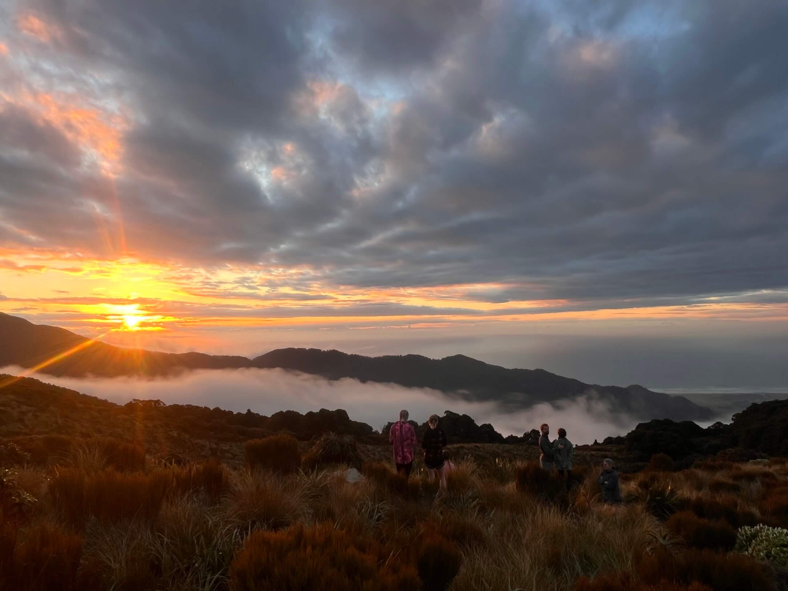
Day 2: It dawned clear, still and full of hope. The climbing started the moment we stepped off the verandah with Herepai Peak (1125 m) and the roller coaster continued over Ruapae, East Peak and West Peak before a food break and a lie-down in the tussock at Walker (1335 m). The views over Horowhenua and out to Kapiti Island were fabulous. It felt humbling to be alone on top of the world.
After Pukemoremore (‘bald hill’) and the turnoff to Dundas Hut, 200 m below, there were more big hills before a gentler section to Arete Hut. Even better – the tiny two-bunker was empty.

Day 3: We were greeted by a dazzling rising sun coming through the hut door. Arete Hut is set in a hollow with spectacular peaks around, which demanded to be spotted before we set off up to Arete Peak (1505m). Five separate river systems flow from this peak, which, according to one account, was known by Māori as hanga o hia tangata – the place that caused surprise to man. Mounts Ruapehu, Taranaki and Tapuae-o-Uneuku were all in sight.


After reaching Pukematawai (‘hill at the head of the waters’) we were joined by a stream of Te Araroa Trail walkers who we passed and were passed by for the rest of the day. They are notable for their shoes (not boots) and lack of gaiters (muddy socks!). The track to Dracophyllum Hut was muddy, but easier going. Peering into the delightful Park Valley, we mused on the theory that it was formed by glaciation in an ice age.
The afternoon was surprisingly tough with lots of small peaks and niggly knobs sapping our energy. It took four hours to cover the five and a half kilometres from Draco to Nichols Hut. Nichols is in a charming basin below the ridge and once we had sat down in the sun outside, we made a fairly instant decision to stop for the night rather than press on to Anderson. 14 people in the eight-bunker was tight, but the walkers were friendly, respectful and caring of each other.

Day 4: The weather was still calm and warm. Our TA hutmates cleared out by 7am, leaving us to eat breakfast alone. After climbing back to the main track, it was up and around a nicely graded ridge, arriving at Mt Crawford (1462 m) in just over an hour. More beautiful tops travel took us to Junction Knob and gently down to Anderson Memorial Hut at the bushline. How delightful to encounter pōpokotea (whitehead), tui and korimako (bell birds) at this sheltered sunny site.

After elevenses on the deck and a water-bottle top up, we dived into the goblin forest. A gentle downhill through gnarled bush, then back to the hills again. At the bottom of Aokaparangi (‘a row of clouds in the sky’), we met a young couple who were walking north to a wedding in Kimbolton. They’d pulled out their party clothes the day before to pose on the Tararua ladder!
Going up and over Aokaparangi required some careful hand and foot placement and was the most technical part of the trip. The wind picked up and the mist rolled in – we felt ready to be finished for the day. But Maungahuka Hut was three hours walk away. It was a long slog over the last few hills and a great joy to see the hut come into view through the mist.

Our exhaustion vanished after a wash down on the verandah and chats with a superb bunch of hut buddies. They included S-K exponent Andy Carruthers himself, who was out with family and friends – a special bonus.
Day 5: The weather gods were stamping their feet. Low visibility, light rain and gusty conditions weren’t ideal for crossing the twin Tararua peaks, Tuiti and Tunui (‘small’ and ‘big’). We ‘ummed and ahhed’ about carrying on the planned route and decided it was safe to continue, as were up for some Type 2 fun. With high winds forecast for the afternoon, we set our sights on Kime Hut for the night rather than risk an unpleasant and potentially unsafe crossing to Alpha.
As someone who has suffered from height fright in the past, the low vis conditions were probably helpful for this leg. The lead up to and exit from the ladder were tricky, but well supported with cables and handholds. There was mud and it got muddier as we ascended and descended the various knobs before a fairly brutal climb to Bridge Peak (1421 m).

From there, it was a stroll over to Kime Hut (being careful to stay on the track). With great relief, we shedded our wet coats and overtrousers, then brewed fresh coffee. We enjoyed an afternoon of eating and sleeping in the lovely company of some of the Maungahuka crowd.
Day 6: The weather was claggy, damp and somewhat uninviting, but the wind had dropped a bit. We awoke with the smug knowledge that our walk over to Alpha Hut would make for a very short day. It took 40 minutes to reach Mt Hector/Pukemoumou (1529 m) (‘hill of desolation’) with its iconic wooden war memorial cross. This was the highest point of our tramp, altitude-wise.
We made quick work of the Dress Circle – no views to linger over and it was getting wetter. This part of the range can be dangerous in parlous winter conditions and a number of people have perished there, including Mr (Esmond) Kime himself. After a decent lurch up to Alpha Peak (1361 m) it’s a 300 m descent to the hut and we finally scored some views out to the east under the cloud.

Our company for the night was a stringy, old-school Coaster – a “climate refugee” who’d headed north to escape a wet El Nino summer. He had very loose plans for the days ahead and was determined to take his time making decisions. (Maybe a lesson for us there?)
Day 7: The weather was still drizzling with low visibility. The two previous short days provided some rest time and we felt strong for the final stretch. First up was a clamber down to Hells Gate, where the Eastern Hutt River rises. Sarah sighted, and we both heard, two long-tailed cuckoos, which was a treat.
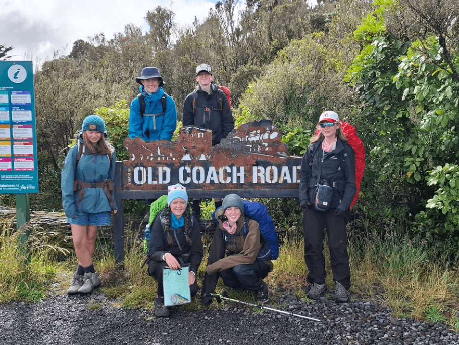
Then we climbed to the legendary and generally disliked Marchant Ridge (due to its length, monotony and mud). But this time, it didn’t seem as bad as we’d remembered. We lunched just below a cold, wet Marchant Peak (1038 m), rolled past the old Dobson Hut site and joined the Puffer Track that led us all the way to the “dusty carpark of glory” (Carruthers). Tired, but happy, it was only a short drive to the pie/ice cream shop and home.
We had walked for a total of 41 hours over seven days, not injured and still friends, and achieved a tops S-K our way.

FMC thanks Mark Wilcox for contributing his story to Wilderlife.
Do you have a backcountry trip or adventure to share? We’d love to hear from you. To learn more, email communications@fmc.org.nz.